


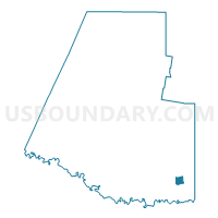
Voting District 0056, Hidalgo County, Texas
About
Outline

Summary
| Unique Area Identifier | 674768 |
| Name | Voting District 0056 |
| County | Hidalgo County |
| State | Texas |
| Area (square miles) | 3.26 |
| Land Area (square miles) | 3.20 |
| Water Area (square miles) | 0.06 |
| % of Land Area | 98.19 |
| % of Water Area | 1.81 |
| Latitude of the Internal Point | 26.13998350 |
| Longtitude of the Internal Point | -97.92813940 |
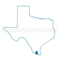
Maps

Graphs
Select a template below for downloading or customizing gragh for Voting District 0056, Hidalgo County, Texas


Neighbors
Neighoring Voting District (by Name) Neighboring Voting District on the Map
- Voting District 0032, Hidalgo County, TX
- Voting District 0040, Hidalgo County, TX
- Voting District 0046, Hidalgo County, TX
- Voting District 0121, Hidalgo County, TX
Top 10 Neighboring County Subdivision (by Population) Neighboring County Subdivision on the Map
Top 10 Neighboring Place (by Population) Neighboring Place on the Map
Top 10 Neighboring Unified School District (by Population) Neighboring Unified School District on the Map
- Weslaco Independent School District, TX (67,754)
- Mercedes Independent School District, TX (20,673)
- Progreso Independent School District, TX (7,463)
Top 10 Neighboring State Legislative District Lower Chamber (by Population) Neighboring State Legislative District Lower Chamber on the Map
Top 10 Neighboring State Legislative District Upper Chamber (by Population) Neighboring State Legislative District Upper Chamber on the Map
Top 10 Neighboring 111th Congressional District (by Population) Neighboring 111th Congressional District on the Map
Top 10 Neighboring Census Tract (by Population) Neighboring Census Tract on the Map
- Census Tract 228, Hidalgo County, TX (9,129)
- Census Tract 231.02, Hidalgo County, TX (7,385)
- Census Tract 231.03, Hidalgo County, TX (6,680)
- Census Tract 231.04, Hidalgo County, TX (5,283)
- Census Tract 230, Hidalgo County, TX (5,262)
- Census Tract 229, Hidalgo County, TX (4,479)